 |
||||
|
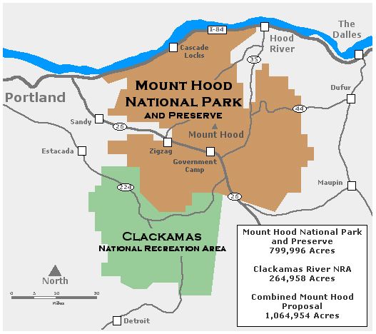
_________________________________________________________ What woud the new park boundaries be?The new Mount Hood National Park would transform today's collection of National Forest and BLM land, and adjacent State Park land into two main units: a national park and preserve for Mount Hood and the Gorge, and a national recreation area for the Clackamas River drainage. The map (below) provides a general view of the proposed boundaries, and more detailed maps will eventually be added to the website. Mount Hood National Park & Preserve: this part of the proposal would cover nearly 800,000 acres, and designate most of the area near Mount Hood and on the Oregon side of the Gorge as national park land, incorporating the loop highway and the associated state parks and waysides that fall along the route. Two areas would be set aside as national preserves: the Bull Run watershed and the eastern slopes of Lookout Mountain. The difference between park and preserve designations is administrative, notably with hunting allowed in national preserves. Both the park and preserves would be administered by the National Park Service. Clackamas National Recreation Area: this 265,000 acre portion of the proposal would cover the entire Clackamas drainage, shifting the management focus to recreation and ecosystem restoration. The area would also be administered by the National Park Service, in tandem with the new Mount Hood National Park. |
||||
 |
||||
 |
||||